










| Areas | 65 districts and places in 5 regions |
|---|---|
| Map | Interactive map |
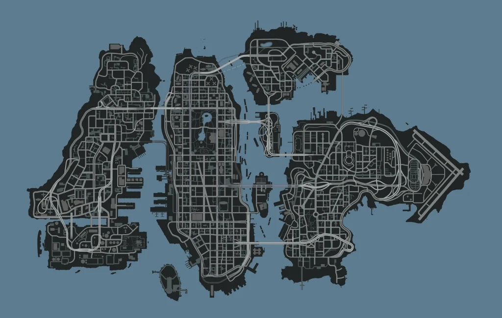
Every district and named area in Grand Theft Auto IV, region by region. Liberty City is split into boroughs. Broker and Dukes are open from the start, and the bridges to Algonquin, Bohan and Alderney open as the story moves on. The map spots column counts the pins on our interactive map that fall in each district (collectibles, weapons, health, armor and more), so it shows where there is most to pick up.
Broker
Where Niko arrives: Hove Beach's Russian community, Firefly Island's funfair and the docks.
| District | Map spots | What is there |
|---|---|---|
| Beechwood City | 3 | 2 Flying Rats, 1 Stunt Jumps |
| Beachgate | 1 | 1 Flying Rats |
| BOABO | 3 | 2 Flying Rats, 1 Stunt Jumps |
| Downtown | 1 | 1 Flying Rats |
| East Hook | 1 | 1 Flying Rats |
| Firefly Island | 4 | 4 Flying Rats |
| Firefly Projects | 3 | 3 Flying Rats |
| Hove Beach | 5 | 4 Flying Rats, 1 Cash Registers |
| Outlook | 2 | 1 Flying Rats, 1 Cash Registers |
| Rotterdam Hill | 1 | 1 Stunt Jumps |
| Schottler | 2 | 2 Flying Rats |
| South Slopes | 2 | 2 Flying Rats |
Dukes
Suburbs, industry and the airport on the eastern side of the city.
| District | Map spots | What is there |
|---|---|---|
| Cerveza Heights | 5 | 2 Flying Rats, 2 Stunt Jumps, 1 Cash Registers |
| East Island City | 5 | 3 Flying Rats, 1 Stunt Jumps, 1 Cash Registers |
| Francis International Airport | 6 | 4 Flying Rats, 2 Stunt Jumps |
| Meadow Hills | ||
| Meadows Park | 3 | 3 Flying Rats |
| Steinway | 13 | 9 Flying Rats, 4 Stunt Jumps |
| Willis | 5 | 4 Flying Rats, 1 Stunt Jumps |
Bohan
The northern borough of housing projects and industry.
| District | Map spots | What is there |
|---|---|---|
| Boulevard | 6 | 5 Flying Rats, 1 Stunt Jumps |
| Chase Point | 2 | 2 Flying Rats |
| Fortside | 2 | 2 Flying Rats |
| Industrial | 6 | 3 Flying Rats, 3 Stunt Jumps |
| Little Bay | 1 | 1 Flying Rats |
| Northern Gardens | 3 | 3 Flying Rats |
| South Bohan | 7 | 6 Flying Rats, 1 Stunt Jumps |
Algonquin
The island at the center: skyscrapers, Star Junction, Middle Park and the outlying islands.
| District | Map spots | What is there |
|---|---|---|
| Castle Gardens | 2 | 2 Flying Rats |
| Castle Garden City | 1 | 1 Flying Rats |
| Chinatown | ||
| City Hall | 3 | 2 Flying Rats, 1 Stunt Jumps |
| Colony Island | 5 | 5 Flying Rats |
| East Holland | 4 | 3 Flying Rats, 1 Stunt Jumps |
| Easton | 1 | 1 Flying Rats |
| Fishmarket North | 2 | 1 Flying Rats, 1 Stunt Jumps |
| Fishmarket South | 2 | 2 Flying Rats |
| Happiness Island | 6 | 6 Flying Rats |
| Hatton Gardens | 3 | 2 Flying Rats, 1 Stunt Jumps |
| Lancaster | 1 | 1 Flying Rats |
| Lancet | 2 | 2 Flying Rats |
| Little Italy | ||
| Lower Easton | ||
| Middle Park | 4 | 4 Flying Rats |
| Middle Park East | 3 | 2 Flying Rats, 1 Stunt Jumps |
| Middle Park West | 2 | 2 Flying Rats |
| North Holland | 6 | 4 Flying Rats, 2 Cash Registers |
| Northwood | 9 | 5 Flying Rats, 4 Stunt Jumps |
| Presidents City | 1 | 1 Flying Rats |
| Purgatory | 2 | 1 Flying Rats, 1 Stunt Jumps |
| Star Junction | 6 | 4 Flying Rats, 2 Stunt Jumps |
| Suffolk | 2 | 2 Flying Rats |
| The Exchange | 4 | 3 Flying Rats, 1 Stunt Jumps |
| The Meat Quarter | 2 | 2 Flying Rats |
| The Triangle | 4 | 3 Flying Rats, 1 Stunt Jumps |
| Varsity Heights | 4 | 4 Flying Rats |
| Westminster | 1 | 1 Flying Rats |
Alderney
The separate state to the west, across the river.
| District | Map spots | What is there |
|---|---|---|
| Acter | 25 | 21 Random Characters, 4 Flying Rats |
| Acter Industrial Park | 11 | 9 Flying Rats, 2 Stunt Jumps |
| Alderney City | 19 | 11 Flying Rats, 7 Stunt Jumps, 1 Cash Registers |
| Alderney State Correctional Facility | ||
| Berchem | 6 | 4 Flying Rats, 1 Stunt Jumps, 1 Cash Registers |
| Leftwood | 8 | 6 Flying Rats, 2 Stunt Jumps |
| Normandy | 2 | 2 Flying Rats |
| Port Tudor | 5 | 4 Flying Rats, 1 Stunt Jumps |
| Tudor | 13 | 9 Flying Rats, 4 Stunt Jumps |
| Westdyke | 10 | 6 Flying Rats, 4 Stunt Jumps |
Sources
District names and regions come from Grand Theft Wiki (text under CC BY-SA 3.0) and its area categories, checked on November 10, 2026. Map spot counts are from our own map.